Trump’s Treachery
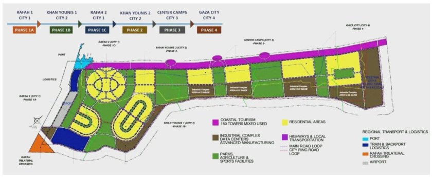
Only after a few minutes of allowing this to sink in does its cruelty more fully reveal itself. First, Gaza and its beaches, the sea and the sunsets are at the heart of the strip — fishing is ingrained into the strip’s culture landscape. All this will be erased by the pink banned of foreign owned and foreign occupied glitzy Dubai-style OTT ostentatious hotels and resorts and serviced apartments.
Second, Gaza today is one of the most densely populated places in the world, yet, the Palestinians that remain there will be segments – Apartheid South African township style – into the yellow shapes (above).
Third, abutting almost all yellow blobs are brown ones – these abut ‘Israel’ thus Israeli businesses will be able to exploit Palestinian labour going forward. Fourth, the orange triangle, the two shades of blue and the grey/white areas tell us that not only will the Palestinians have no direct access to their coastline but neither will they have direct access to Egypt and the outside world. The airport, port and boarder crossing are all set to remain permanently in Israels control. Thus, Palestine’s marine resources (fisheries oil and gas) will all be owned by Israel. . .
Dwell on the map a little longer and then it will dawn on you that this is evidently what is also unfolding in the Occupied West Bank. The plan is clear; the West Bank will end up looking just like this ‘Gaza Plan’ . . .

